Showing posts with label Seattle Community Gardening History Project. Show all posts

Tuesday, August 30, 2022

How do you move a garden? Part three: The Interbay P-Patch


"You don't just inherit dirt here, you inherit the past, whoever was there planting things." -- Donna Kalka, gardener

Sandwiched between 15th Avenue NW and the railroad tracks, in the cleft between the Queen Anne and Magnolia hills, lies a sort-of no man's land. Part tide lands, part low-lying swale, the Interbay area has been used for everything from a dump to a parking lot, to railroad yards and light industry, to athletic fields and golf courses.

And a P-Patch.


The Interbay P-Patch was founded in 1974, just one year after the start of the city's P-Patch program. In point of fact, informal gardening may have been going on for some time on the little used acres prior to the official opening. Some 47 acres of property were (and are) managed by the Seattle Parks Department; the P-Patch, on one acre at the heart of the site, was surrounded by athletic fields and a golf course. Squeezed on all sides, it was just a matter of time before, like Sand Point and Eastlake, the patch would be forced to fight for its life. However, unlike those two gardens, Interbay had to move not once, but twice.

Lowlands

The Interbay area was named for its location between Smith Cove, an arm of Elliott Bay, and Salmon Bay, on the Ship Canal. From the P-Patch today one can see huge cruise ships on the horizon at the Smith Cove terminal to the south. Fisherman's Terminal at Salmon Bay lies to the north. Active railroad tracks define the western boundary, while busy 15th Avenue West provide the eastern edge.

Early in the 20th century, the Olmsted Brothers landscape firm, hired by the city to design a parks system, recommended that the tidal lands at Smith Cove be filled to create athletic fields for " big boys and young men." The reasoning ran that "The big boys are usually better able to afford car fare to outlying parts of the city where larger ballfields can be afforded and where there are relatively fewer small boys." (1908 Olmsted Report to City of Seattle Parks Commission). Girls did not factor into the report in the context of ball games. 

It would be many decades before anything like the Olmsted vision became a reality at Interbay. Before that happened, a portion of the land became a small dump for ten years (1916-26). Subsequently the city purchased private lands in the area with a view to establishing a small municipal airport. When that project failed to materialize, the land was devoted again to dumping -- this time on a larger scale.

The five-room Interbay School opened in 1903 at 16th NW and Barrett Street; it was de-activated in 1939 and torn down in 1948. Control of the land was turned over to the parks department.

Early in the 1960s, the open dump was converted to the increasingly popular sanitary landfill model in which garbage piles are covered with soil every day. 

In 1962 a portion of the landfill was leveled to be used on a short-term basis for overflow parking for the Century 21 World's Fair down the road. A bit later, the sanitary fill gave way to athletic fields and a 9-hole public golf course with driving range and mini-golf course. 

At one point, Interbay was proposed as the site of the Kingdome. A site adjacent to Seattle's Chinatown/International District was selected instead.

Garbage piles up at the Interbay Dump, September 22, 1944. Courtesy Seattle Municipal Archives, Image #40412.

 This map, labeled "Smith Cove Sanitary Fill Area to be reserved for future airport site," shows the proposed airport outlined in heavy black. It is dated October 15, 1946. No such facility was built. Instead the area was returned to dumping. Courtesy Seattle Municipal Archives, Image #1162.

Looking down at Interbay from the Gilman Avenue incline, 1960. The open garbage dump has been converted to a sanitary fill opening up possibilities for other uses. The streets and the fill appear to be awash with rain water. Courtesy Seattle Municipal Archives, Image #29357.


Interbay landfill site converted to use as a parking lot, 1962. 


In the mid-1970s parks engineer Don Sherwood created one of his famous diagrams of Seattle's parks for Interbay. It depicts the golf facilities on the south end of the fill lands and ball fields on the north. The original p-patch is sketched in at middle-right. (Sherwood Files) According to Don Sherwood's notes, and depicted above, the small golf course and driving range existed for a few years from 1966 on the southern half of the property. The miniature golf course shown at lower left stood approximately where the current p-patch is today.


Laying sod on the Interbay Playfield on the north end of what is now the Interbay Athletic Complex, 1967. Courtesy Seattle Municipal Archives, Image #29344.


The First Move


For several years the gardeners at Interbay were left to tend their crops in peace. Then, in the late 1970s rumors began flying that the city hoped to, once again, redevelop the public golf course at Interbay, one that promised to be a vast improvement over the derelict Interbay Golf Park. The available site was huge -- about 47 acres -- and the p-patch, in the middle of the expanse, took up just a bit more than one of these. Nonetheless, it seemed that the small garden was in the way. In 1981, gardeners won a City Council resolution guaranteeing them one acre of garden space. Unfortunately, the exact location for that space was not specified.

One of the original patchers complained in a letter to the Seattle Times:

"Me, now, I've been working the same plot at Interbay for six years. Started with a pile of rocks and clay. You oughta see the soil now, dark and rich and producing enough to feed me and all the neighbors. Seems a shame that next year folks are going to be stomping through this fine soil with their golf clubs. Didn't know they needed such grand soil for golfing." (Grace E. Carpenter, July 11, 1979.)

After several years of negotiation and protest, in 1992, the p-patch moved to the Northeast corner of the landfill site. Gardeners did most of the heavy lifting, ferrying their precious soil and plants over to the new site in wheelbarrows. Interbay Two (or New Interbay) lasted only four years before it was again threatened by the plans for the yet-to-be-built new golf course. Once again, the p-patchers manned the barricades!

The Second Move


Incensed by the threatened move so soon after the last one, gardeners took a proactive stance, orchestrating a campaign that included media outreach, circulation of a short documentary about the peril to the garden, and many, many phone calls to the city council. Long time gardener and site coordinator Ray Schutte remembers urging his fellow patchers to be relentless:

"I said we have to build our defense very slowly and timely. And I bored them to death by playing Bolero at top volume on my little boombox in the garden until they begged -- we get the message! Don't have to tell us anymore. So we basically, by the hundreds across the city, tied up the lines to the city council. I remember one council person told me afterwards, she says, 'You know, it was insane. That's all we did was answer the phone all day long cause there were hundreds of people calling."

Despite the effort, the final council vote regarding the p-patch, was 5 to 4 in favor of moving again. However, the group was able to leverage the publicity they had gotten into a highly favorable and formal agreement with the city, an agreement that included
  • Being able to choose their own site
  • Substantial funds to pay for the move
  • Physical assistance for the move
  • New soil to replace the clay cover
  • Raised beds; and
  • An irrigation system.

In many respects, the new garden site, in the sunny southeastern corner of the fill, was superior to the previous one. For one thing, it was not directly behind the driving range as once planned!

Down to the Soil


Much work remained to be done at the new site. The soil provided by the city was sterile, without the living organisms necessary to organic gardening. It was up to the gardeners to augment it with compost and liquid fish emulsions. A year later they rejoiced each time someone found a worm in their patch:

"They would pick it up hold it up into the air and shout WORM! And everybody would come over and look at it." (Ray Schutte)

With help from the parks department, the garden was able to recycle materials from other sites. Old paving stones from Alki Beach were used to make the main paths in the garden, along with granite pavers that could not be used at Westlake Plaza. A flag pole from the World's Fair flag pavilion was planted at the gathering space.  A greenhouse was donated by a neighbor selling his property. 

Many more improvements and artistic touches have been added to what is now, hopefully, the permanent home of this 132-plot p-patch, one of the jewels of the program. 


An enormous cruise ship at the Smith Cover terminal appears to be just a stone's throw from the garden. 2022.


An old acetylene tank, a gift from a local business, is repurposed into a "gathering bell," calling folks to communal meals. 2022.


Tall net fencing separates the garden from the golf course. Stray balls do come through often and are given to golfing gardeners to "recycle." 2022.


Thanks to Ray Schutte, Donna Kalka, and Jude Berman for their oral history interviews.


This post is a part of the Seattle Community Gardening History Project. 
🌿 


Sunday, August 21, 2022

How do you move a garden? Part two: The Eastlake P-Patch


The Eastlake neighborhood of Seattle boasts a lovely community garden nearly hidden from view down a steep embankment. In the 1990s, gardeners pulled together to fight threats to their patch. In contrast to the Sand Point P-Patch, the Eastlake garden was located on public land controlled by the city. Unfortunately, this did not guarantee protection when developers came calling. Eastlake had no park such as Magnuson Park at Sand Point to which they could move the garden. In fact, the neighborhood with breathtaking views of Lake Union and the Olympic Mountains had very little green space at all. Faced with this situation, the community decided to combine their efforts and fight for both the garden and a new park.


The Shelby Street right-of-way in 1941. Eastlake Avenue is at top; Fairview Avenue at bottom. The lower portion of the hill is the site of the original p-patch. Courtesy Seattle Municipal Archives, Image #39970.


The top of the incline was used as a makeshift parking lot for businesses on Eastlake Avenue, including Covey Laundry. Courtesy Seattle Municipal Archives, Image #39961, 1941.


Rough Start

The story of Eastlake P-Patch dates to 1981 when a small group of neighbors, about 10 families, banded together to carve out a garden where the Shelby Street right-of-way met Fairview Avenue on the shore of Lake Union. Barbara Donnette remembers the ordeal of hacking out blackberry vines and weeds only to find piles of garbage underneath it all:

"We ultimately cleared the land, hauled away all of the debris that had collected there -- there were old car parts, old appliances deteriorating, carpeting -- you name it! And I spent quite a lot of time. We had a Volkswagen bus and at the time you could dump at the transfer station. I remember being really stuffed up in my nose after the trips with the carpeting and the mold. It was pretty awful. Anyway, we carved out 18 200-square foot plots."

The neighborhood now had a P-patch. Unfortunately, it was only a few years before real estate development put the squeeze on the garden. The demolition of a building on Eastlake Avenue was the first challenge when the city gave the owners permission to funnel trucks and dumpsters down through the right-of-way, directly through the patch. For a brief space of time gardeners coped with a reduced footprint. 

Then, early in the 1990s, construction of a new building on Eastlake Avenue threatened to take over the garden completely. The P-patch had run afoul of "interim use." However, this time the community revolted, organized, and demanded not only that the garden be preserved, but that the undeveloped green space directly north of the construction site be purchased by the city and made into a park. 


The Eastlake P-Patch in 2004 before the build-out of the upper portion. Courtesy Seattle Municipal Archives.

Moving things around

Thanks to the efforts of the Eastlake Community Council, the P-patchers, and a variety of other advocates, the dream of a combined park and p-patch became a reality in 1998. The group formed to honcho the effort, the Olmsted-Fairview Park Commission, honored the vision of the Olmsted Brothers landscape company which a century earlier had recommended small parks along Seattle's waterways, including Lake Union. City, county, and state funding was mobilized to allow the city to purchase land on both sides of the Shelby Street right-of-way from private owners. In 1995 the community celebrated the successful land acquisition with a blackberry festival.

The P-Patch was relocated to accommodate the design of the park. However, the move was not far -- a few feet to the south. As at Sand Point, the gardeners hoped to take their plants and the soil they had worked on to the new site. However, under cramped conditions and with heavy equipment in the way, it was difficult. The soil that was moved had to be augmented to become fertile again. Little was left of the old garden.


The Kroll map published in 2000 shows the Shelby Street right-of-way labeled "Not Open" and plats below it already named "Fairview Olmstead [sic]," the park to come. 

The Patch Rises

The Fairview Olmsted Park (now generally referred to as Fairview Park) was laid out during the winter of 1998-99. The design was created by Nakano/Dennis landscape architects (now Nakano Associates).

Since that time three fundraising efforts, each anchored by a Department of Neighborhoods Matching Fund grant, led to infrastructure improvements. Most significantly, grants obtained in 2009 allowed the garden to expand uphill. Today the garden holds 47 plots.

The garden shed was constructed with funds raised in 2000.


The Eastlake P-Patch in 2022 showing the lower and upper gardens.


Stairsteps connect Eastlake Avenue at the top of the incline down to Fairview Park (at right) and the Eastlake P-Patch (at left), 2022.

Whimsical art can be found throughout the garden.

In the (Cheshiahud) Loop

Today the Eastlake P-patch and Fairview Park are stops along the Cheshiahud Loop, a series of interconnected paths, alleys, and streets that encircle Lake Union. Small pocket parks can be found at several street ends along Fairview. The loop is named in honor of a Duwamish elder who lived in the area with his wife for many years.


The view from the Eastlake P-Patch and Fairview Park, 2022.


Thanks to Barbara Donnette for her oral history interview.


This post is a part of the Seattle Community Gardening History Project. 

🌿


Sunday, July 31, 2022

How do you move a garden? Part one: The Sand Point P-Patch


Part I: Sand Point


In an earlier post, we described the loss of a P-Patch on 27th Avenue NE near Eckstein Middle School. Some of the gardeners from 27th Avenue were able to acquire plots at the Sand Point P-Patch approximately two miles east along Sand Point Way. This property, too, fell to development, in 2001, making way for a new facility for Seattle Children’s Hospital, the owner of the land. However, unlike some gardens mentioned here, the Sand Point P-Patch did not die, but was moved wholesale across the street to Magnuson Park.

Farming Tradition on the Sand Point Peninsula

From the early 1900s small farms could be found dotting the Sand Point Peninsula in the northeast sector of the greater Seattle area along Lake Washington. In the early 1910s, a group of Japanese farmers formed a collective community at the south end of the peninsula. This group included the parents of Gordon Hirabayashi, who was born at Sand Point in 1918. The Hirabayashis and others decided to move south to Auburn, but other Japanese families stayed on.


The circa 1925 photo above, courtesy of Densho, shows the Uyeji family on the porch of their home just off Sand Point Way. This property is approximately where the federal archives building now stands.


Photos in the Puget Sound Regional Archives property records document several Japanese homes that were confiscated and torn down early in World War II to make room for Naval housing in support of the Sand Point Naval Air Station. The families were, of course, removed to internment camps. This property was just north of NE 65th Street, where condos stand today.


The Kroll insurance map printed in the early 1940s shows the property that had been leased Japanese farms, the Orth and Gilbert 10-Acre Tracts. The northern section became the Sand Point P-Patch in the 1970s. The area pictured was not annexed by the city until 1942.

Revival of Farming

The Sand Point P-Patch took shape in 1977, early in the days of the city's P-Patch program. It was located on the site of old navy housing associated with the Sand Point Naval Air Station. (Some say it was quonset huts.) The structures had been pulled down, though remnants remained in the form of foundations and apple trees. Neighborhood children remember playing in and around the foundations of the old housing in the 60s. The abandoned railroad tracks immediately adjacent to the property were pulled up in the mid-70s and officially became the Burke Gilman Trail in 1978. Naval Station Seattle still occupied the peninsula to the east, across Sand Point Way, although flights from the base ceased in 1970.

At some point, the tract had been transferred to the U.S. Forest Service, a division of the Department of Agriculture. In 1982 the feds declared the land surplus. Various entities expressed an interest in it; when the dust cleared Children's Orthopedic Hospital (now simply Seattle Children's) emerged as the owner in 1984. However, it would be another 17 years before the hospital decided on a use for the land. During that time, the P-Patch continued to operate under an annual lease arrangement.

In 2001 the Sand Point P-Patch, which had occupied the site for nearly a quarter century, fell victim to the common theme of "temporary use." The hospital decided to move ahead with  development in 1998 and notified the gardeners that they would be ousted. Some in the p-patch community protested their eviction, asking for a small portion of the land to remain as a garden and even touting the therapeutic benefits of a garden for patients. 

When it became clear that the p-patch could not remain on the hospital grounds, the city offered gardeners the chance to create a new, larger patch across the street at Magnuson Park, the former navy base. Rather than simply giving up their hard-hoed plots and starting afresh, 33 of the 50 patchers decided to move their gardens bodily -- plants, soil, and all. What followed was a coordinated effort between the gardeners, the parks department, and the hospital to make this happen.

P-Patch Manager Rich Macdonald wrote to the team in charge of the development of the park:

"The Sand Point Naval Station is a logical site for relocation of the garden. Only at Sand Point is sufficient space and sunlight available to permit the P-Patch gardeners to design and build a beautiful new garden with their usual public amenities. community gardens have bee proposed previously for Sant Pint, although with the [imminent] loss of the present P-Patch, the need is greater than in the past." (Rich Macdonald to Sand Point Operations, City of Seattle, June 19, 1998, Seattle Municipal Archives)


Diagram of the Sand Point P-Patch in 1986. Courtesy Seattle Municipal Archives.

Choosing the Site

Magnuson Park is huge and, in 2000, was much less developed than it is today. Three p-patchers who happened to be employees of NOAA next door to the park undertook the task of selecting a suitable site for the new garden. They found it on a sunny hillside that had likely been constructed from the rubble of old runways that had run directly below it. They tested the soil to make sure it was healthy. 

Marty DeLong was the volunteer coordinator for the move. She describes how the new garden became much more than a simple P-Patch:

"The old place was a "P-patch." This had to be a "community garden" because it was inside the park. And that's why we have the children's garden. We have native plants, we have the native plant nursery. We have the orchard. Those things were kind of insisted upon."

Moving a Garden

So how does one move a garden? It may not be as simple as staking out a new patch and starting over. Dedicated gardeners will want to move their plants, artwork, trees and shrubs that define the garden, and, perhaps most importantly, the soil. Gardeners interviewed for this project stressed the importance of retaining soil that they had built up over years with judicious application of compost and soil amendments. 

"So in the fall of 2001 -- the hospital was wonderful. They sent their grounds crew over with big flatbed trucks because we dug up all of our plants that we wanted to take over. And then we thought we could dig up some of the little trees and we couldn't! So they went back to the hospital and got their big -- whatever they're called -- and dug them up. We took the cherry tree that was there because someone had died in the garden and it was the memorial cherry tree. We took a lilac, we took a pear, we took a fig, and then just lots of perennials that we had here and there." (Marty DeLong)

A bit of negotiation with the hospital regarding the soil turned out to be a win-win situation.

"They had to remove soil to level [the ground], The contractor was going to have to take the soil up to Everett to dump it. We had worked on that soil for years. We made a deal. They could haul it across the street and save them 60 miles round trip. And we get the soil that we had been enriching over all these years.

So they were wonderful. And we meanwhile had been busily digging up our own personal gardens. And then we took everything over, and there's kind of a little swale beside the garden that's now part of the native plant nursery, but nobody was there then. And we put all our plants there and covered them with straw because it was the fall." (Marty DeLong)

Kathy Dugaw was also involved in the move and in setting up the new garden at Magnuson. The timing of the move -- right after the events of 9/11 -- is something that sticks in her mind:

"Right after 9/11. Yeah. Easy to remember. Oh, and it was, it was so strange walking over there. I mean, 'cause it was deadly quiet because usually we're in a traffic pattern for the planes and there were no airplanes or anything like that. It was weird." (Kathy Dugaw)

Today the Magnuson Community Garden is a showpiece consisting of seven different components: an orchard, a native plant border, a native plant nursery, a tranquil garden, an amphitheater, a children's garden, and the p-patch which now has plots for 140 gardeners. Much more can and will be said about the diversity of talent and volunteerism that went toward creating this special place.


Magnuson P-Patch, summer 2022.


Seattle Children's 70th and Sand Point Administrative Building stands roughly where the Sand Point P-Patch was located. The main hospital campus is approximately two miles to the south.


Nothing remains of the old p-patch; however, a bench and plaque on the Burke Gilman Trail immediately adjacent to the old garden at the corner of NE 70th commemorates one of the stalwart gardeners. Maxine Wolfheim suffered a fatal heart attack while gardening.

Thanks to Marty DeLong, Kathy Dugaw, and Mark Huston for oral history interviews.

This post is a part of the Seattle Community Gardening History Project. 

🌿

Friday, May 20, 2022

Seattle's Victory Gardens


Victory Garden at Seattle Children's Home, 1944. Courtesy MOHAI, Seattle Post-Intelligencer Photograph Collection, 1986.5.7817.3, photo by Ed Watton.

From victory gardens to p-patches, Seattle has a long history of community gardening. A straight line links the victory gardens of old with the p-patches, community gardens, and pandemic gardens of today. In particular the idea of vacant land as an untapped resource continues, although such unused plots are harder to find today than they once were.

During World War II a cooperative “Victory Garden” was developed in the heart of Seattle’s Ravenna neighborhood, not far from today’s Ravenna Community Center. According to a piece in The Seattle Times, the garden was “serving seven families for a cost of only $3.58 each.” What that amount represented or how it was calculated is not stated.

Victory Gardens abounded around the Seattle area, as they did throughout the nation at war. Framed as a way of easing the strain on the country’s agricultural resources while ameliorating the privations of war on family households, gardening was equally a way of channeling patriotism – something that could be done on the home front.

Most gardens were small scale, home-based efforts which served to supplement household provisions during a time of food rationing. Such was the garden of the Gibbon family in the Pritchard Island neighborhood of Southeast Seattle. However, Americans were also urged to make use of vacant lots, a project that would no doubt take several families working in cooperation, such as that at Ravenna.


Rosetta Gibbon and son Gary tend their victory garden on the shores of Lake Washington, c. 1943. Photo courtesy of Rainier Valley Historical Society.


Victory gardens cropped up on corner lots, in schoolyards, at public housing projects, and on army bases. Some corporations sponsored gardens next to their plants. Japanese Americans planted victory gardens in the camps where they were incarcerated during the war, while their farms and greenhouses back home in the exclusion zone were turned over to others to raise essential vegetables for the war effort.

An ambitious suggestion for a victory garden plan, courtesy of the state of Illinois.


In 1943 Orrin Hale, chair of the Seattle Civilian War Commission’s Victory Garden Committee called for registering vacant parcels throughout the city:

“There is a great deal of vacant property in Seattle that could be made available for victory gardens to people living in apartments, or homes built on small lots. We are appealing to owners of this property to turn their lots over for cultivation this year.”

The World War II Victory Garden was not a new idea. Similar efforts were made during The Great War although on a smaller scale. The terms “war garden” and “liberty garden” were used often at that time.

Women's Work


While all able-bodied civilians were encouraged to support the war effort, the target demographic for war garden work was women, particularly housewives and mothers who were less likely to become Rosie the Riveters. Government agencies, the media, and businesses all found a new appreciation for women as part of the war effort and as consumers. Seattle was no exception

“Women are being urged locally to interest themselves generally in the movement for more and better gardens. While gardening under normal conditions is essentially a man’s job, and every man with the right spirit and with facilities for gardening will roll up his sleeves and get busy, much depends on the women of this city and of the nation to make the greatest success of the movement for war gardens.” (SDT March 17, 1918)

The tone changed little two decades later. Newspaper advertisements featured attractive slacks-clad women planting and hoeing under headlines such as “Every Practical Housekeeper is planting a 1943 Victory Garden.”

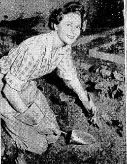
Nurseries and “seed dealers” were quick to jump on the bandwagon, offering to “instruct housewives in growing vegetables in home gardens” and coming up with creative packages of seeds, tools, and instruction booklets for the patriotic gardener. And, of course, fashion could not be neglected. A 1943 “article” advertised Frederick & Nelson’s “At Home Week” (“A Thrilling Event Keyed to Victory”). The article features a photo of a smiling young woman wielding a trowel in Frederick & Nelson’s miniature victory garden (third floor.) “Wearing nail-head studded denim jeans, gay plaid shirt and sturdy Mexican huaraches, Mrs. Philip Bronson ‘digs in for victory’.


Seattle Daily Times, March 19, 1943.


Interest in home-grown produce waned after the war as women returned to traditional gender roles and food shortages decreased. However, by the 1960s a back-to-the-earth movement brought a resurgence of community gardening and laid the groundwork for the start of Seattle's P-Patch Program in 1973.


This post is a part of the Seattle Community Gardening History Project. 

🌿


Farming Revival in the Rainier Valley

"Inch by inch, row by row, someone bless these seeds I sow." 

(The Garden Song, David Mallett)

Today the landscape of Seattle is dotted with tiny gardens called P-patches, as well as several larger urban farms and orchards. Rainier Valley is no exception; a number of vacant lots and underutilized spaces have been converted to meet the growing desire for freshly-grown produce and the need for food security. Some of these spaces are dedicated to the newer groups of immigrants and refugees who have settled in the valley.

The City of Seattle, through its P-patch program, and the Seattle Housing Authority have made concerted efforts to provide gardening space for newcomers. Many of these families come from farming backgrounds and a space to plant and harvest familiar foods is a way to ease the transition to their new home. 

Rainier Valley also boasts a demonstration orchard in Hillman City, as well as the Rainier Beach Urban Farm and Wetland, developed on the site of the city’s old Atlantic City Nursery, and the showpiece Bradner Gardens Park.

Whimsical art at Climbing Water P-Patch


A patchwork of patches

More than a dozen P-patches are scattered around the valley. The big housing communities at NewHolly and Rainier Vista each offer several parcels of land for gardening. In addition, each community provides a farm stand where gardeners may sell their extra produce. (These are currently closed to the COVID pandemic.) The Hillside P-Patch near Franklin High School is farmed by Cambodian immigrants on a steep incline that was once part of the Vacca Farm and served as "cheap seats" for kids wanting to watch games at Sick Stadium. Climbing Water, named for the adjacent hill-climbing Cedar River pipeline, is a narrow, terraced garden sandwiched between apartments that recalls the hillside gardens of the old Italian residents of Garlic Gulch. The Thistle patch, one of the oldest and largest in the city, provides 77 plots for East Asian immigrants and others in Rainier Beach. And the smaller NewHolly 29 Avenue garden serves East African, Southeast Asian, and Chinese American residents of the NewHolly community. 

Longtime gardeners Plekeao and Mansak Douangdala came to Seattle in 1981 from a refugee camp in Thailand after fleeing communists in their home country of Laos. They first started gardening on a plot of land provided by Our Lady of Mount Virgin church. Many years later, Mansak discovered an overgrown parcel of land on Estelle Street and began to mow the city-owned property. Now the couple cultivates a large garden plot at the Estelle Street P-patch where they raise bitter melons, eggplants, yam root, taro leaf, onions, peppers, corn and mustard greens.


Rainier Beach Urban Farm and Wetlands, 2022

Farm in the city

In 2010, Rainier Beach Urban Farm and Wetlands was established on the site of a defunct city nursery in the Pritchard Island neighborhood of Southeast Seattle. The 11-acre nursery, which grew plants for the city's parks and utility properties, occupied the land from about 1937 to 2010. Some old greenhouses and sheds remain. Atlantic City Nursery and neighboring parkland existed on land reclaimed from Lake Washington when that body of water was deliberately lowered in 1916 by the opening of the Ship Canal. Much of it is still wetland. The neighborhood, no longer an island after the lake lowering, was also at one time the site of a Duwamish Indian settlement.

Today, RBUFW is run as a cooperative garden and educational farm in a partnership between the City of Seattle, Tilth Alliance, and Friends of the Rainier Beach Urban Farm and Wetlands. There are no individual plots at Rainier Beach. Instead, the land is managed in a way to promote education and advocacy, all while producing fresh produce for the benefit of the community.

In an interview, Sue Gibbs, a founding member of RBUFW, described some of the challenges the project faced in transforming the acreage into a working and welcoming space:

"It was a complex design team, because there's so much going on here. We had an architect, an urban farm specialist, a wetland specialist. We finally chose Berger Partnerships, they're landscape architects. So we were on the upswing and then, boom!, the farm was closed for a while [for construction]. We had just planted a bunch of fruit trees the year before; they were still young and then they didn't get pruned and shaped. We had to rebuild the volunteer network, the staffing here at the farm, rebuild the Friends board. And that was starting to go really well, and then COVID hit." (2022 oral history)

Despite these challenges, the farm has been able to take shape, offering space and programs for a diverse community. On any given day there may be a group of East African elders working on their crops, a gaggle of pre-schoolers on a field trip, young adults in the school district's Bridges Program learning vocational and social skills. The farm also offers a Community Supported Agriculture (CSA) program; in addition to paid subscriptions, CSA produce goes to various food programs. A children's garden and a U-pick area, a modern communal kitchen and meeting room -- all serve to fulfill the vision of the founders, in the words of Sue Gibbs, "a healthy, safe place for people to grow, live, and grow their families."

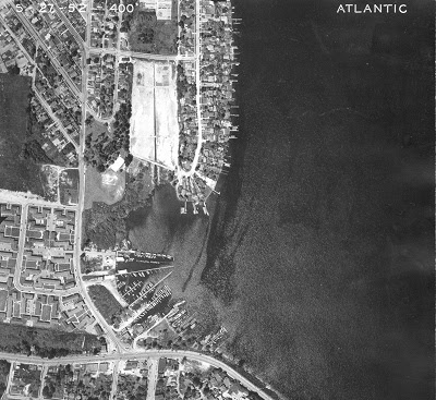
1952 aerial showing the old Atlantic City Nursery. Courtesy Seattle Municipal Archives, Don Sherwood Parks Collection.

A refuge for all

The site of Bradner Gardens Park has seen multiple layers of use. When Bradner P-Patch in the Mount Baker neighborhood was founded in 1987 it still had school portables on the grounds from the time it was used as a middle school annex (1971-1975). Until 1993 the structures were used by a nonprofit, Central Youth and Family Services. And prior to all of that it had been the site of  the Quinsite-Bradner housing project (1942-53), emergency housing for veterans returning from World War II and the Korean conflict. Some folks still recall these "temporaries" around town that lasted much longer than the five years planned. 

Originally set up to provide space for Mien refugees from Laos in the 1980s, the Mount Baker garden overcame a serious threat. Long-time gardener and activist Joyce Moty described how the neighborhood banded together to protest the city’s decision to sell the land in the mid-1990s:


 “The Southeast Atlantic Community Association – we had a two-year battle with city hall over trying to save this piece of land from being sold for market rate housing. And we went to the mayor's office, talked to city council people, trying to say this is really not a good idea to sell this land, but we were just citizens.” (2021 oral history) 


Ultimately, the group was instrumental in getting an initiative titled Protect Our Parks passed; the 1996 law states that the city may not sell park land without replacing it in the same neighborhood. Today Bradner Gardens Park offers a children’s garden, demonstration beds, a bee colony, art installations, and basketball hoops, in addition to its 61 P-patch beds.


Bradner Gardens, 2021. The garden on Mount Baker hill enjoys a view of downtown Seattle. Sadly, the community building seen at right was damaged by arson a few years ago.

This post is a part of the Seattle Community Gardening History Project. Thanks to Mansak Douangdala (interviewed by Nancy Dulaney), Joyce Moty, Sue Gibbs, and Valentina Barei for their oral history interviews.

What's in a Name? The Kirke Park and P-Patch

Every garden has a story. Tucked into a quiet neighborhood of Ballard is a garden with a particularly unique back story: The Kirke Park and P-Patch.


Remnants

Those with a basic understanding of Germanic languages will recognize that the word Kirke means “church.” The park was given a Norwegian name to honor the Scandinavian heritage of the Ballard neighborhood. However, there was a more specific reason for the name: Kirke Park sits on the site of a religious community that once occupied the property for nearly 80 years – not a traditional house of worship as one might find in many neighborhoods, but the residence of a millennialist sect known as the Seventh Elect Church in Israel. Founded in 1922 by a 77-year old preacher, the church dictated chastity, vegetarianism, unshorn hair, and an unquestioning obedience to the authority of its founder, Daniel Salwt. Tall, imposing, with a long-white beard, Salwt ruled over a group of several dozen adherents who handed over property and money to his use, including a parcel of land on Ninth Avenue Northwest Avenue in Ballard.

Thanks to research carried out by the late Barbara Hainley and other neighbors, we know quite a bit about Mr. Salwt, a charismatic, itinerant preacher from the Midwest who arrived in Seattle in 1910 at the age of 65. Attracting followers from among the mill workers and other laborers, he gathered the “elect” to the Ballard property. To house the faithful, he moved (or possibly tore down and rebuilt) a wooden hotel or rooming house to the site, a structure he had also been given. A second, smaller building followed. There, with promises of eternal life, his followers lived communally, turning over their wages to the church and growing vegetables on plots assigned to them. Members also tended fruit trees, berry bushes, and ornamental flower beds. A tradition of gardening and self-sufficiency was established.

When Salwt died at the age of 84 in 1929, church members, believing he was an incarnation of Jesus and that he would rise again, refused to turn over his body to authorities until threatened with legal action. In the following decades a dwindling number of men lived on the church property, the last two dying in the millennial year 2000. The gardens were maintained, at least sporadically. An article in the Seattle Times from 1970 noted that while the church buildings were “somewhat run-down, the extensive flower gardens are neat and well tended.”[i]


            The name SALWT, laid out in bricks, was still to be seen when plans for the park got underway. Photo courtesy of architect Clayton Beaudoin.


End Times

The world did not come to an end, as Salwt had predicted; however, his church did. By 2008, the legal entity that was the Seventh Elect Church was heading for dissolution and the heir to the property was ready to sell. Neighbors had had their eyes on the property for some time and successfully lobbied the city to purchase the land for a small park. With funds from the 2000 Pro Parks Levy and the 2008 Parks & Green Space Levy, the decrepit buildings were torn down and a multi-use park designed by landscape architect Clayton Beaudoin of SiteWorkshop. The park includes a playground, an open meadow, a 31-plot p-patch, a large giving garden, a communal strawberry patch, and many “secret” nooks and crannies.


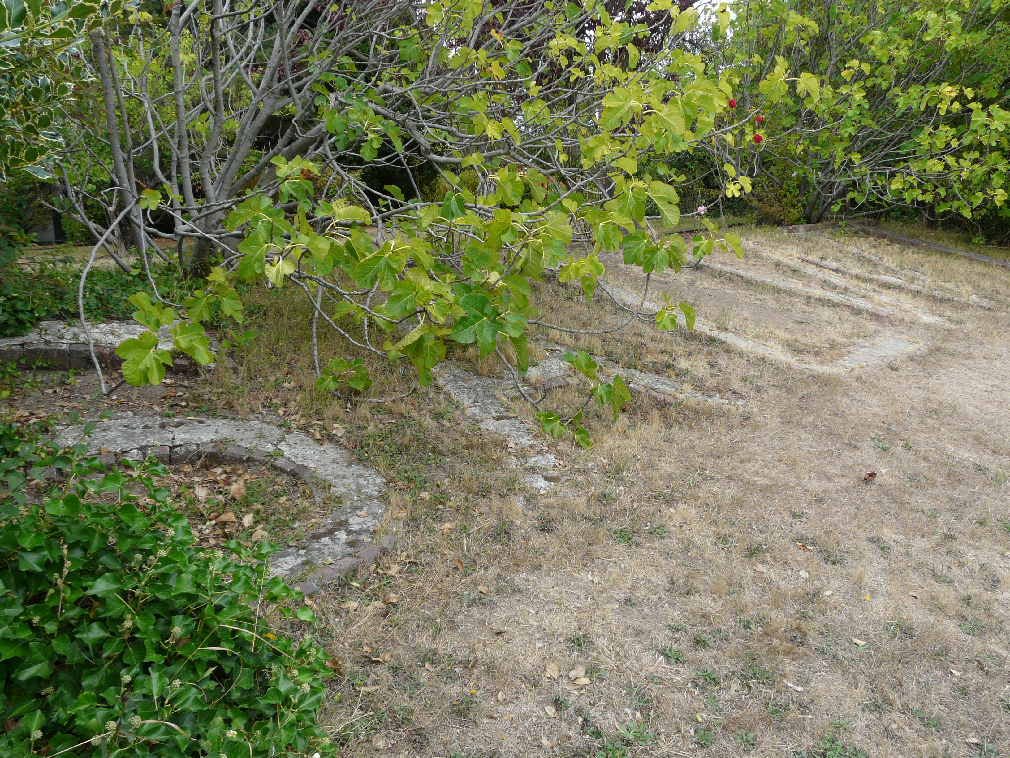
Kirke is one of our city’s newest parks, dedicated in 2012, but its history is evident in more than just its name. A plaque explains the unusual story of the property. Several concrete foundation walls that were to support a temple that was never built have been reshaped and repurposed to create the illusion of a walled secret garden. The garden shed, designed and built by neighbor and gardener Jennifer Hammill, mimics a picturesque chapel. A few shrubs and trees original to the church’s garden have been retained, including an espaliered apple tree and roses. Beaudoin recalls that “there were many elements that created a sense of ‘ruins’ and we heard many requests to maintain the magic and mystery of the place.”

Friends of Kirke Park, a group of neighbors and gardeners, coordinates garden activities – both work parties, including a Spring Cleanup, and purely social events such as the annual summer Hot Dog Party. Interested community members are invited to contact the Friends by sending a message to kirkeparksea@gmail.com

Kirke Park is located at 7028 9th Avenue N.W. in Seattle.


This post is a product of the Seattle Community Gardening History Project. A version of this story was published in the GROW P-Patch Post, Spring 2022.


[i] Seattle Times, May 6, 1970, A9. Other sources for this story include an oral history interview with Jennifer Hammill, correspondence with Clayton Beaudoin, and an article by Barbara Hainley titled “The Seventh Elect Church in Israel: Seattle’s ‘Long-Haired Preachers,” published in Communal Societies, Journal of the Communal Studies Association, 35:2 (2015).

Thursday, May 19, 2022

Losing Ground: Seattle's Lost Patches

Over the course of a half century, Seattle has developed well over 100 p-patch gardens. Not all have survived. Too often, patches have suffered by being labeled “interim use.” The pressures of urban development coupled with rising property values brought down a number of gardens. Other succumbed to social conflict, both external and internal, and other factors. Today we will look at a few of the patches that were forced to close permanently and the circumstances behind the closures.

Jackson Place

In 1995 the Jackson Place Community Council applied for and received a modest grant from the Department of Neighborhood’s Matching Fund Program to establish a p-patch. The grant application spoke of “the opportunity to beautify our community, take advantage of one of the numerous vacant lots, and have a focus for developing and fostering neighborhood friendships and pride in our community.” The street corner lot was located at 16th Avenue S. and S. Weller Street on the western slope of the city’s Central District. Former P-Patch Program Manager Rich Macdonald remembers it as “a little garden with a little view. It was really pretty.” Unfortunately, only six years later the owner of the property, a food processing company, terminated the lease likely due to dissolution of company assets preparatory to becoming inactive. Today the corner is a parking lot.

The loss of Jackson Place did provide an added incentive for the build-out of the creatively designed and named Climbing Water P-Patch, just two blocks to the south on a steep slope adjacent to the Cedar River pipeline. Climbing Water was established in 2006 on land leased from HomeSight, an affordable housing developer, and with the support of the Jackson Place Community Council.

                        The short-lived Jackson Place P-Patch. Courtesy Seattle Municipal Archives.


                                            Steep and narrow Climbing Water P-Patch


Beacon Avenue P-Patch

On Central Beacon Hill, around the corner from the Beacon Avenue thoroughfare, a small community garden sits tucked away from the street behind heavy shrubbery on S. Graham Street. The land is owned by the adjacent Bethany (formerly Beacon Avenue) United Church of Christ. The property had been gardened for some time by members of the church, but -- in an effort to expand the gardening base in 1993 -- the church agreed to turn over management of the garden to the P-Patch Program. The relationship endured for thirteen years, but ultimately came to an end in 2005. The garden faced obstacles that included its placement between private properties and lack of any street frontage, making it difficult for patchers to deliver materials to the garden. Layered on top of this were ongoing personality conflicts between several gardeners whose disputes were left to program staff to mediate. Ultimately the city decided these difficulties and the resulting fall-off of interest in gardening made effective management impossible.

Some years later, in 2016, the garden space was turned over to a nonprofit organization, Nurturing Roots, which has created a small urban farm complete with gardening workshops, communal meals, chickens, and a commitment to social and environmental justice. Nurturing Roots leases the property from Bethany Church.


Chickens at Nurturing Roots Farm


Angeline

Perhaps the most heartbreaking loss was that of Angeline P-Patch, a garden that existed for a scant 18 months. Angeline and Ferdinand were two gardens established by the city in the summer of 1982 on vacant land under power lines on Beacon Hill. The patches were intended to serve Southeast Asian refugees, many of whom had settled in the area. Families from Laos and Cambodia had been violently uprooted from their homes due to fallout from the Vietnam War. The new patches were the city’s first effort to find land for these one-time farmers to cultivate and grow some of the vegetables of their homeland. Angeline was offered to ethnic Mien families.

Unfortunately, the best laid intentions ran afoul of culture clash. A few neighbors of the Angeline patch orchestrated a campaign against the garden, calling it a public nuisance. The Beacon Hill Community Council became involved. Concerns ranged from children playing in the street to vermin to newcomers washing their cars on the street and asking for favors from residents, such as use of a telephone (in the pre-cell phone era). One neighbor complained that the garden was messy and weedy, likely not recognizing Asian vegetables or understanding the Mien practice of letting plants go to seed in order to preserve the seeds for future planting. Possibly the greatest concern was the habit of the Asians to work in their plots late into the evening, even after dark with the help of flashlights. From the perspective of 40 years, it becomes clear that cultural practices on both sides were in conflict. A few isolated incidents, compounded by language barriers, likely led to an overblown reaction from a few neighbors.

P-Patch staff spent most of 1983 struggling to address the concerns of the neighbors while also working with the gardeners to curb some practices. In the summer of 1983, one of the most disgruntled neighbors hired an environmental consultant firm to test the garden for suspected vermin infestation, harmful bacteria, and human waste. None was found. Unfortunately, it was too late to save the garden. By autumn, the efforts were abandoned and the garden was set for closure at the end of the year.

For the 1984 growing season, families who wished to continue gardening were assisted to find plots at the Ferdinand patch a few blocks away or at the more distant Thistle P-Patch in Rainier Beach.


Site of the Angeline P-Patch returned to nature

NE 75th Street and 27th Avenue NE

In 1978 the P-Patch program was able to lease a parcel of land downhill from Eckstein Middle School in Northeast Seattle for the low low price of $85 per year. Sometimes known as Hillside, sometimes as Ravenna Hillside, but generally referred to now as that garden where the skinny houses are, the 16-plot patch lasted for a decade. The land was owned by a retired couple who lived in Okanogan County. Upon the death of the husband, the wife made the hard decision to sell the land noting that she was “sorry to see the Pea [sic] Patch go.” 

The tale of 27th Avenue demonstrates the risk of siting p-patches on private land. With only a short-term lease (generally one to three years), gardeners run the risk of being uprooted at almost any time.


Plan of the Ravenna Hillside P-Patch


Sand Point

Some of the gardeners from 27th Avenue were able to acquire plots at the Sand Point P-Patch approximately two miles east along Sand Point Way. This property, too, would fall to development, in 2001 making way for a new facility for Seattle Children’s Hospital, the owner of the land. However, unlike some gardens mentioned here, the Sand Point P-Patch did not die, but was moved wholesale across the street to Magnuson Park. The story of that heroic effort is told here.

This post is a part of the Seattle Community Gardening History Project. 

🌿